Reading the Weather Outdoors: Clouds, Pressure, Wind and Storm Safety
Reading the weather outdoors comes down to three things you can observe without an app: which clouds are in the sky and how they change, whether air pressure is falling or rising, and which way the wind is shifting. A sky that fills from the west with high, hooked cirrus, a halo around the sun and a falling barometer usually means rain within a day; cumulus that towers up by midday warns of afternoon thunderstorms.
This guide explains the main cloud types, pressure and wind signs, the old sayings that actually hold (and those that do not), and the thunderstorm rules every outdoor person should know – plus where not to pitch camp when cold air and fog settle at night. It is part of the core bushcraft skill set and complements an official forecast rather than replacing it.
Step by step
-
1

Look at the sky every hour
Note cloud type, height and trend: are clouds growing, thickening and lowering, or shrinking and breaking up?
-
2

Track the pressure trend
Check a barometer or altimeter watch regularly. A fall of about 3 hPa in 3 hours often means worsening weather.
-
3

Notice wind shifts
A wind turning anticlockwise – for example west to south-west to south – often announces an approaching front.
-
4

Watch for warning signs
Cumulus towering up by midday, a halo around the sun or a darkening western sky call for a plan B.
-
5

Act early when thunder starts
Count from flash to thunder: under 30 seconds, head for safer ground now. Wait 30 minutes after the last thunder.
-
6

Choose a weather-safe camp
Avoid hollows where cold air and fog collect, exposed ridges, lone trees and dry stream beds.
Why reading the weather still matters with a forecast
Forecasts from national weather services are the best starting point for any trip – check them before you leave, and check the warnings. But forecasts cover large areas, and in hills, valleys and forests the weather you actually get can differ by hours or by a whole valley. Phones lose signal, batteries die, and a thunderstorm that was "possible in the afternoon" becomes very real at 2 pm on an exposed ridge.
Reading the sky fills this gap. It tells you whether the forecast is arriving early or late, whether that shower cloud is growing into a storm, and whether tonight will be clear and cold or cloudy and mild. That matters for everyday decisions: when to pitch the tarp, whether to collect dry firewood now (see fire in wet weather), which layer of clothing to wear, and when to turn back.
Official forecast vs. your own observations
Forecast / warning app
- Big picture for the next days
- Official storm and heat warnings
- Needs signal or an update before you go
- Coarse in mountains and valleys
Reading the sky
- Works anywhere, no battery
- Shows what is happening now, locally
- Good for the next few hours
- Limited beyond about a day
Cloud types and what they mean
Meteorologists sort clouds by height. In temperate latitudes, high clouds (cirrus, cirrostratus, cirrocumulus) sit roughly 5–13 km up and consist of ice crystals; mid-level clouds (altostratus, altocumulus) sit about 2–7 km up; low clouds (stratus, stratocumulus, nimbostratus, cumulus) form below about 2 km. The towering cumulonimbus – the thunderstorm cloud – can stretch from low levels right up to the top.

| Cloud | How it looks | What it often means |
|---|---|---|
| Cirrus | Thin white wisps, often with hooks ("mares' tails") | Fair now; if it thickens and spreads from the west, a front may follow within about a day |
| Cirrostratus | Milky veil, sun still visible, often with a halo | Moisture increasing high up; rain or snow often follows |
| Altostratus | Grey sheet, sun like behind frosted glass | Front close; rain often within hours |
| Nimbostratus | Dark, low, featureless layer | Steady rain or snow for hours |
| Cumulus (small, flat) | Cotton-wool heaps with flat bases | Fair weather, usually dissolve in the evening |
| Cumulus congestus | Tall, cauliflower-like towers | Showers; possible thunderstorms later |
| Cumulonimbus | Huge tower with a flat, spreading anvil top | Thunderstorm, heavy rain, hail, gusts |
| Stratus / fog | Grey low layer, hills hidden | Drizzle, poor visibility; often lifts during the day |
The most important skill is not naming a cloud but reading the trend. Clouds that thicken, lower and spread over hours usually bring widespread rain. Clouds that grow upwards fast bring showers and storms. Clouds that shrink, flatten and break up in the evening mean calmer weather.
The classic warm-front sequence
In westerly weather, as in much of Europe and North America, a warm front often announces itself a day in advance through a typical order of clouds, each lower and thicker than the one before:
Clouds before a warm front
 1Cirrus spreads in
Thin, hooked wisps appear from the west and slowly thicken. On their own they mean little – many cirrus days stay fine – but a spreading, thickening sheet is the first hint.
 2Veil and halo
A milky cirrostratus veil covers the sky and a ring appears around the sun or moon. The sun still casts shadows. Rain often follows within roughly a day, but not always.
 3Altostratus
The sky turns grey, the sun looks like it is behind frosted glass and shadows disappear. Rain is now often only hours away – pitch your tarp and bring in dry wood.
 4Nimbostratus
A low, dark, uniform layer brings steady rain or snow, often for many hours. Behind the front, the weather usually becomes milder and more humid.
Pressure trends: the barometer in your pocket
Air pressure on its own says little; the trend over a few hours says a lot. Falling pressure means low-pressure weather is coming closer, rising pressure means it is moving away or high pressure is building. Many outdoor watches and some phones contain a barometer; a small analogue barometer works too.
| Change in 3 h | Trend | Typical meaning |
|---|---|---|
| Rising steadily | Improving | Clearing, often cooler and windier at first after a front |
| ±1 hPa | Steady | Current weather likely to continue |
| Falling about 1–3 hPa | Worsening slowly | Clouds thickening, rain possible later |
| Falling more than about 3 hPa | Worsening | Front or low approaching, wind and rain likely |
| Falling about 6 hPa or more | Rapid fall | Strong wind or storm possible – take it seriously |
Rules of thumb for mid-latitudes. Combine them with clouds and wind; local effects in mountains can differ.
Altimeter watches: the trap and the trick
An altimeter measures height through air pressure. Near sea level, a change of 1 hPa corresponds to roughly 8 m of height. If you sleep at camp and your watch says you "climbed" 30–40 m overnight, pressure has fallen by roughly 4–5 hPa – a warning sign. Many watches have a "barometer mode" that holds the altitude fixed while you are stationary; use it at camp, and switch back to altimeter mode when you walk, otherwise weather changes distort your height readings (and height changes distort your weather readings).
Write the pressure in your notebook morning, midday and evening. After a few trips you learn how fast your area's weather changes and how much warning a falling barometer gives you.
Wind shifts and what they announce
Watch where the wind comes from – smoke from your fire, the tops of trees, clouds drifting overhead. In the northern hemisphere, a wind that backs (turns anticlockwise, e.g. from west to south-west to south) often means a low or warm front is approaching. A wind that veers (turns clockwise, e.g. from south-west to west to north-west), often with gusts and a sudden drop in temperature, usually marks the passage of a cold front, followed by showers and then clearing skies. In the southern hemisphere the directions are reversed.
A second clue is the difference between the wind at the surface and the movement of the clouds: if high clouds move from a clearly different direction than the wind you feel, the weather is often changing. Local winds complicate the picture: in valleys and mountains, winds blow up-slope during the day and down-slope at night, and sea breezes turn on the coast. The wind chill calculator shows how much colder a stiff wind makes the air feel.
Wind signs at a glance (northern hemisphere)
- Backing wind, falling pressure
- Front approaching, rain likely
- Veering wind, sudden gusts, temperature drop
- Cold front passing, showers, then clearing
- Calm, clear evening
- Cold night, dew or frost, fog in hollows
- Wind picking up in the evening
- Weather change likely during the night
Red sky, halos and other weather sayings: which ones work?
Many weather sayings contain a real observation, because they were collected by farmers and sailors in westerly weather zones. Others are pure folklore. Here is what holds up:
"Red sky at night, shepherd's delight"
In the evening you look west, where the weather comes from. A red sunset means the sun is shining through clear air in the west and lighting clouds overhead from below – the clouds are leaving, clear air is arriving. In the morning you look east: a red sunrise means the sun lights clouds that are arriving from the west – and the weather may worsen. The rule works reasonably well in mid-latitude westerly weather, but not every time.

| Sign | Claim | How reliable | Why |
|---|---|---|---|
| Red evening sky | Fair weather tomorrow | Moderate | Clear air to the west in westerly weather |
| Red morning sky | Rain later | Moderate | Clouds arriving from the west are lit from below |
| Halo around sun or moon | Rain or snow soon | Moderate | Ice-crystal veil of an approaching front; not every halo brings rain |
| Morning dew or frost | Fine day | Fairly good | Clear, calm night – usually under high pressure |
| Fair-weather cumulus dissolving in the evening | Settled weather | Good | Stable air |
| Stars twinkling strongly | Weather change | Weak | Depends on turbulence high up, not only on weather |
| Animals behaving oddly | Storm coming | Unreliable | Too many other causes |
The halo deserves a closer look: a ring of about 22° radius (roughly a hand-span at arm's length) around the sun or moon, created by ice crystals in cirrostratus. Because this veil often runs ahead of a warm front, a halo is a good early hint – confirm it with a falling barometer and thickening clouds.
Thunderstorms: warning signs and the 30/30 rule
Thunderstorms are the most dangerous weather for people outdoors in summer: lightning, sudden gusts, hail, heavy rain and flash floods. In most of Europe and North America they are most likely on warm, humid afternoons, and in mountains they often build faster than in the lowlands. Many form within a few hours, so watching the sky from late morning on pays off.
How a summer thunderstorm builds
 1Small cumulus in the morning
Small, flat cumulus with clean edges on a sunny morning are normal. Note how many there are and how high they reach.
 2Growing taller
By late morning some clouds grow much taller than they are wide. On a warm, humid day this is the moment to adjust the plan: shorter route, earlier descent.
 3Hard, bright towers
Towers with sharp, cauliflower edges shooting up by midday are a clear warning. Leave summits and ridges now, not when the first thunder rolls.
 4Anvil and thunder
A flat, spreading anvil top, a dark base and rumbling thunder mean the storm is mature. Count the seconds between flash and thunder and act at once.
The 30/30 rule – and why earlier is better
Sound travels about 1 km in 3 seconds. Count the seconds between the flash and the thunder: under 30 seconds means the storm is roughly 10 km away or closer – close enough to strike you. Then wait 30 minutes after the last thunder before you return to exposed ground, because lightning can strike well away from the rain. Many weather services now simplify this: if you can hear thunder at all, you are within reach of lightning. The safest reaction is to move before the storm arrives. The thunderstorm distance calculator turns your count into a distance and a next step.
If you are caught outside, reduce your exposure step by step:
Reducing lightning risk when you cannot reach shelter
 1Get off high ground
Leave summits, ridges and open slopes immediately and descend towards lower, less exposed terrain. Keep away from metal cables, fences and via-ferrata wires.
 2Avoid lone trees and water
Never shelter under a single tree, a mast or a lone rock pinnacle. Get out of and away from water. Uniform, lower forest is less exposed than open ground or isolated trees, but not safe.
 3Spread the group
Keep several metres between people – many outdoor schools suggest around 15 m – so one strike cannot injure everybody and others can give first aid.
 4Crouch as a last resort
If a strike seems imminent (hair standing up, buzzing), crouch on an insulating pad or rucksack, feet together, head down, hands over your ears. This only slightly reduces the risk; do not lie flat.
Anyone struck by lightning does not carry an electrical charge and can be touched safely. Call the emergency number immediately and start CPR if the person is not breathing – see emergency signals and calling for help and keep a first aid kit at hand.
Valley fog, cold air pools and where not to camp
On clear, calm nights the ground loses heat quickly, and the air near it cools. Cold air is heavier than warm air, so it flows downhill like water and collects in hollows, valley floors and clearings surrounded by forest. These cold air pools are often several degrees colder than the slope a little higher up – enough to turn a comfortable night into a freezing one. If the air is moist, radiation fog forms in the same places, soaking gear with dew and often lasting into the morning.

Weather check for a camp site
- Not in a hollow or on the lowest valley floor on clear, calm nights
- Not on summits, ridges or next to the tallest tree in a thunderstorm season
- Not in dry stream beds, gullies or close to rivers that can rise after heavy rain upstream
- No dead trees or large dead branches overhead – wind brings them down
- Tarp opening turned away from the prevailing wind and the expected weather
- A slightly raised spot a little up the slope for drainage and warmth
The full method for choosing a spot is in choosing a camp site, and the tarp pitch planner suggests a pitch for the wind and rain you expect. In winter, cold air pools matter even more – see winter camping.
How strong is the wind? Reading the Beaufort scale from trees
Wind direction tells you what is coming; wind strength decides whether your tarp holds, whether your fire is safe and whether you should be in the forest at all. You do not need an anemometer – the Beaufort scale was designed for estimating wind by eye, and trees make excellent gauges.
| Beaufort | Speed | What you see | What it means at camp |
|---|---|---|---|
| 3 | 12–19 km/h | Leaves and small twigs in constant motion | Ideal: tarp dries, smoke clears; fire manageable |
| 4 | 20–28 km/h | Small branches move, dust and dry leaves lift | Pitch low, tension guylines; sparks travel further |
| 5 | 29–38 km/h | Small trees in leaf sway | Tarp edge to the wind; keep the fire small or skip it |
| 6 | 39–49 km/h | Large branches move, wires whistle | Storm-pitch the tarp; no open fire; check trees overhead |
| 7 | 50–61 km/h | Whole trees sway, walking against the wind is hard | Avoid camping under tall trees; consider leaving the forest |
| 8+ | 62 km/h and more | Twigs and branches break off | Stay out of forests; find open, sheltered ground or a building |
Gusts can be much stronger than the average wind; the wind and Beaufort camp calculator converts forecast wind and gusts for you. On ridges and summits, wind is often one or two Beaufort levels higher than in the valley.
The main danger in a storm is not the wind itself but what it brings down. Dead trees, hanging branches and trees with shallow roots on soaked ground fall first – this is why checking for widowmakers matters more on windy nights than on calm ones. Many forestry authorities advise staying out of woodland entirely during storm warnings and for some time afterwards, because damaged trees keep falling.
For shelter, wind means a lower pitch with fewer open sides. Re-tension the ridgeline and guylines after the first gusts, because cord stretches and fabric settles; an adjustable hitch such as the taut-line hitch makes this quick. Wind also increases heat loss dramatically – at 0 °C, a 30 km/h wind feels roughly like −6 °C, as the wind chill calculator shows – so windy nights call for an extra layer and a warmer sleep system.
Weather hazards by season: heat, cold, dry spells and snow
Each season has its typical weather risks, and knowing them tells you which signs to watch most closely. The table is written for temperate Europe and similar climates in North America; mountains and continental interiors bring more extremes.
| Season | Main risks | Signs to watch | Practical response |
|---|---|---|---|
| Spring | Rapid changes, cold nights after warm days, late frost, showers with hail | Clear evenings, fast-growing cumulus, cold fronts with gusts | Pack for frost even in May; keep rain gear on top |
| Summer | Thunderstorms, heat, dehydration, dry fuel and fire danger | Humid mornings, cumulus towering by midday, long dry spells | Start early, rest at midday, drink more, follow fire bans |
| Autumn | Storms, long rain periods, fog, shorter days | Falling pressure, backing wind, clear calm nights for fog | Check trees overhead, plan for darkness, carry dry spare layers |
| Winter | Cold, wind chill, snow, freezing rain, very short days | Clear calm nights, snow clouds from the north or east, rain near 0 °C | Warmer sleep system, sheltered camp, strict turnaround times |
Heat and drought
On hot days, the weather risk is inside your body. Water needs rise steeply with heat and effort; the water needs calculator shows how much to carry and where you must refill. Plan hard work for the cool morning hours and rest in the shade at midday. Long dry spells also turn the forest into fuel: many countries publish a forest fire danger rating, and in high danger levels open fires are often banned. Check the rules in fire bans and danger levels before you light anything.
Cold, wet and snow
The most dangerous weather for campers in temperate climates is often not deep frost but wet cold around 0–10 °C with wind: clothes soak, insulation stops working and hypothermia creeps in slowly. Keep one dry layer in a waterproof bag, change wet socks early to prevent trench foot and choose your sleeping gear for the coldest likely night, not the average – the sleeping bag and pad calculator helps. Rain falling at or just below freezing can form glaze ice on paths and gear; snow that falls on a still-warm tarp melts, refreezes and adds weight, so knock it off regularly.
Using forecasts, rain radar and warnings well
Reading the sky works best together with good forecasts, not instead of them. A few habits make official information much more useful outdoors.
Forecast terms explained
- "30 % chance of rain"
- In similar situations, rain falls at a given place in about 3 of 10 cases – not "rain for 30 % of the day"
- Showers vs. rain
- Showers are short and patchy (often 10–30 minutes); frontal rain is widespread and can last for hours
- Rain radar
- Shows where rain is falling now; good for timing the next 1–2 hours
- Watch / yellow warning
- Conditions possible or likely – adjust plans and keep checking
- Warning / amber or red
- Dangerous weather expected or occurring – change or cancel plans
Use the national weather service of the country you are in – for example the Met Office in the UK, the National Weather Service in the USA or the Deutscher Wetterdienst in Germany – and a dedicated mountain forecast when you go into the hills, because valley forecasts underestimate wind and storms at height. Download the forecast before you lose signal, and note the expected timing of fronts in your notebook so you can compare them with the sky; a few quiet minutes at a sit spot each day build that habit of watching.
How long will the rain last?
Your own observations answer this surprisingly well. A dark shower cloud with a clear edge behind it usually passes within half an hour – wait under your bivvy or tarp rather than packing up. A uniform grey sky with steady rain and still-falling pressure means hours of rain, often until a wind shift and rising pressure mark the end of the front. Rain is also a resource: a tarp corner can fill a pot in minutes, which is covered in collecting rainwater – treat it before drinking if it runs off dirty surfaces. And if the wet spell lasts, see camping in the rain; a well-planned camp layout for bad weather keeps the kitchen, the fire and your sleeping area dry.
A simple weather routine for every trip
Daily weather routine
- Before you leaveRead the official forecast and warnings, note sunset time with the daylight calculator.
- MorningNote clouds, wind direction and pressure. Dew or frost? Red sunrise?
- Late morningAre cumulus growing tall? Decide on a turnaround time.
- AfternoonCompare pressure with the morning; watch the western sky.
- EveningClear and calm? Camp above the hollow. Wind rising? Secure the tarp.
Should I change my plan?
Is there thunder, or are towering clouds growing fast?
Yes → Leave exposed ground now and head for lower terrain or a building.No → Continue.Has pressure fallen more than about 3 hPa in 3 hours?
Yes → Expect wind and rain; shorten the route and prepare camp early.No → Continue.Is the sky thickening from the west with a halo or grey veil?
Yes → Rain is likely within hours to a day; collect dry wood and pitch well.No → The weather is probably holding – keep watching.
Weather reading pairs well with natural navigation: both train you to look up and around rather than at a screen. Allow extra time on your route when the weather turns – the hiking time calculator helps you plan realistic distances – and browse all bushcraft skills for more.
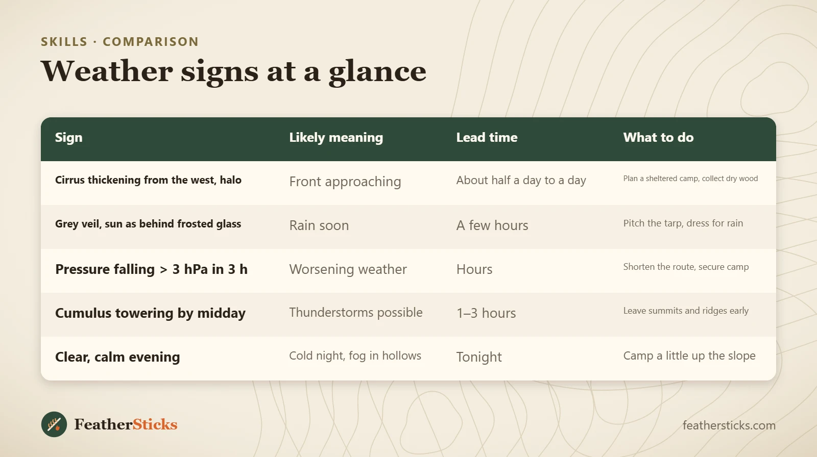
| Sign | Likely meaning | Lead time | What to do |
|---|---|---|---|
| Cirrus thickening from the west, halo | Front approaching | About half a day to a day | Plan a sheltered camp, collect dry wood |
| Grey veil, sun as behind frosted glass | Rain soon | A few hours | Pitch the tarp, dress for rain |
| Pressure falling > 3 hPa in 3 h | Worsening weather | Hours | Shorten the route, secure camp |
| Cumulus towering by midday | Thunderstorms possible | 1–3 hours | Leave summits and ridges early |
| Clear, calm evening | Cold night, fog in hollows | Tonight | Camp a little up the slope |
Common mistakes
- Relying only on an app forecast and never looking up.
- Waiting for the first thunder before leaving an exposed ridge.
- Sheltering from a storm under a lone tree or in a shallow cave.
- Pitching camp in a hollow or on a valley floor on a clear, calm night.
- Reading an altimeter watch as a barometer while walking up and down hills.
- Trusting a single sign, such as one red sunset, instead of combining several.
What you need
- Barometer or altimeter watch with barometer mode
- Small notebook and pencil for pressure and cloud notes
- Rain gear and an extra warm layer
- Tarp and guylines that can be re-pitched quickly
- Insulating sit pad (also for the lightning crouch)
- Headlamp for storms that arrive at dusk
Calculators for this topic
FAQ
How can I predict the weather without an app?
Is "red sky at night, shepherd's delight" true?
What does a ring around the sun or moon mean?
How far away is a thunderstorm?
What should I do if I am caught in a thunderstorm while hiking?
How much pressure drop means bad weather?
Why is it colder at the bottom of a valley at night?
How can I tell how strong the wind is without instruments?
Is it safe to be in the forest during a storm?
Check yourself
Completed6 quick questions from this guide. Nothing is sent anywhere.
Related step-by-step guides
-
 1
-
 1
-
 1